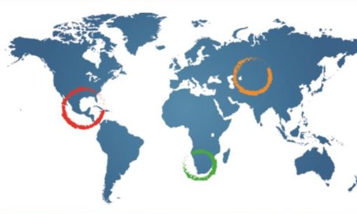
The impact of natural and anthropogenic activities on groundwater resources cannot be overemphasised globally and in Southern Africa. Implementing the available practical measures to protect groundwater from contaminants/pollutants are long overdue. The UNESCO-IHP, in its Governance of Groundwater Resources in Transboundary Aquifers Phase III Project (GGRETA-3) aims to strengthen regional stability, cooperation, and peace by establishing cooperative frameworks for transboundary groundwater governance in River Basin Organisations (RBOs), Regional Commissions, and selected aquifers systems in Africa, among other regions. The focus is to find practical solutions to sustainability challenges related to transboundary groundwater resources, including groundwater quality protection. One such practical solution includes maps to support actions toward groundwater quality protection. With support from WaterNET, GGRETA-3, developed base maps for two transboundary aquifers in the Cuvelai and Limpopo Basin to evaluate aquifer vulnerability. Various literature sources show that in a given aquifer, conditions that may lead to undesirable results for degraded groundwater quality may result from localised pollution due to both natural and artificial contamination. Therefore, identifying (zoning) the areas where an aquifer is more vulnerable to contamination can guide decision-makers to act towards groundwater quality protection. This course demonstrates how GIS-based map development through an overlay index approach leads to supporting actions toward groundwater quality protection. The course has four modules, (1) Protection measures for groundwater quality in transboundary aquifers, (2) Groundwater contaminants/pollutants and their characterisations, (3) Risk assessments techniques for zoning aquifer vulnerability, and (4) Step-by-step guidelines on aquifer zoning: Groundwater protection.
Learning Objectives
- To demonstrate methods and techniques for evaluating practical measures for groundwater quality protection;
- To expose learners to practical skills in mapping sources of potential groundwater pollution/contaminants and characterising such pollutants/contaminants
- To expose learners to practical risk assessments techniques for zoning aquifer vulnerability in the selected aquifer system
- To orient learners on aquifer zoning towards groundwater quality protection in River Basin Organizations [Providing practical step-by-step guidelines].
Work Load
The programme will consist of four modules, each running over two weeks.
- This course will be delivered through presentations, reading materials, videos and quizzes. 3 hours per module is allocated
Course Structure
The modules that will be presented are listed below:
Module 1: Protection measures for groundwater quality in transboundary aquifers
The focus of this module's learning is to improve participants' practical understanding of protection measures for groundwater quality in transboundary aquifer systems. Groundwater quality is usually evaluated spatially and temporally using databases to create maps. Such maps display the possibility of pollution arriving at particular locations in the groundwater system. The least vulnerable areas are moderately vulnerable areas exposed to some pollutants but only when continually discharged or leached. These areas are identified and mapped. Maps show spatial assessments in the form of a susceptibility matrix map that includes the aquifer's vulnerability and its relative importance in classification. Maps can also be used to show qualitative measures of the relative ease with which anthropogenic activities can potentially contaminate a groundwater system.
Module 2:Groundwater contaminants/pollutants and their characterisations
In this module, the focus will be on characterising groundwater contaminants, including natural and manmade. Contaminants found in groundwater cover a broad range of physical, inorganic, and organic chemicals and radioactive parameters. The increasing trends of industrial effluents, including municipal sewage, are the main sources of organic contaminants in groundwater. To reduce the level of contamination, plans can be developed to combat the menace. We plan to discuss the sources of contaminants, their movement, and remedial measures to stop further groundwater contamination. We will use the Tuli-Karoo transboundary aquifer system as our case study. The module time will be broken: into a welcome note, lecture presentations, a case study, and an assessment (quiz).
Module 3:Risk assessments techniques for zoning aquifer vulnerability
In this module, the focus is on the planned management of groundwater resources. One way to protect groundwater quantity and quality is the regional zoning of groundwater resources. Regional zoning means classifying a given region with regard to hydrogeological characteristics and evaluating and determining each zone's possible use. The necessary assumption is the appropriate knowledge of geological structure (compiled in a geological map) and hydrogeological conditions (compiled in a hydrogeological map). The basis for subdivision is a hydrogeological unit distinguished and delineated based on lithological, stratigraphical, structural, and hydrogeological characteristics. It should have a distinct hydrological system. The hydrogeological region is the basic unit. Regions may be grouped into larger units, such as hydrogeological provinces. When applicable, the subdivision of regions into hydrogeological zones or subzones forms the basis for a groundwater development plan. We will use the Tuli-Karoo and Cuvelai Transboundary Aquifers as our case studies. The module time will be divided into welcome remarks, lecture presentations, a case study, and an assessment (quiz).
Module 4: Step-by-step guidelines on aquifer zoning: Groundwater protection
The focus of this module's learning is to improve participants' practical understanding of the steps that need to be mastered when conducting aquifer zoning activities in the field. Reflect on the feasibility of such activities in different aquifer setting environments. It is expected that participants will provide reflective feedback on reinforcement and modifications to the designed step-by-step guides on aquifer zoning.
Meet the Course Instructors
Dr Kawawa Banda
Dr Kawawa Banda is an academic in the Department of Geology, School of Mines at the University of Zambia. He holds a PhD degree in Environmental Engineering (with a strong focus on Hydrogeology) from the Technical University of Denmark (DTU) in Denmark, an MSc (Integrated Water Resources Management) and a BSc (Geology) both from the University of Zambia. His research interests are in Hydrogeology, Remote Sensing, Environmental Geology and Water Resources Management with over ten years of experience with several publications and consultancy in these fields. Dr Banda is a reviewer of several internationally accredited journals.
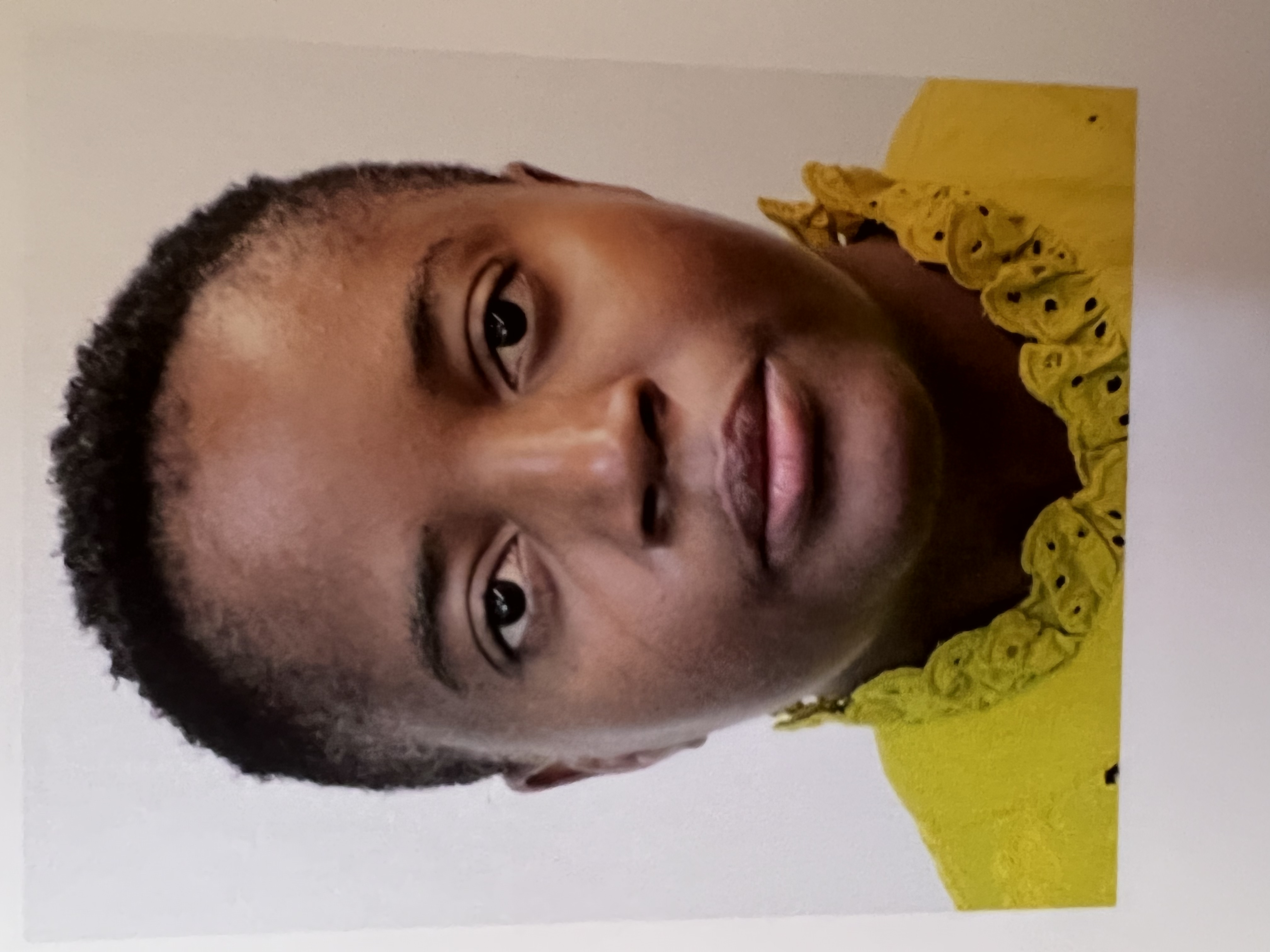
Dr Josefina Tulimevava Hamutoko
Dr Josefina Tulimevava Hamutoko is currently a lecturer at the Department of Geosciences of the University for Namibia and a Post-doc research fellow at the Southern African Science Service Centre for Climate Change and Adaptive Land Management (SASSCAL) in Namibia. She holds a PhD in Geology from the University of Namibia, focusing on Hydrogeology, MSc in Environmental Resource Management from Brandenburg Technical University Cottbus-Seftenberg in Germany. Her research interests are in Water Resources Management, Hydrogeology and Remote Sensing, with over five years of experience in several publications.
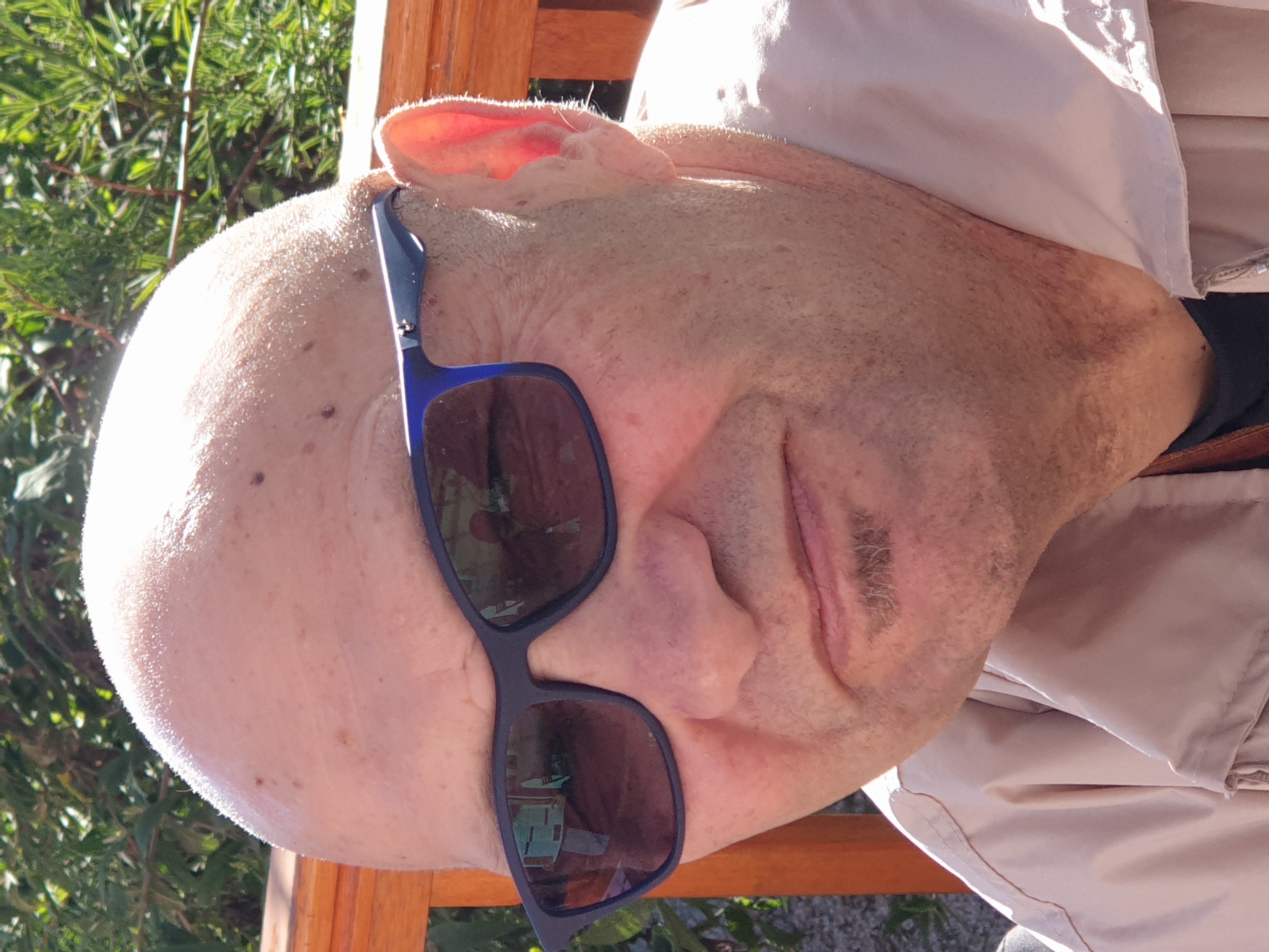
Dr Kevin Pietersen
Dr Kevin Pietersen has 30+ years of experience in the water, environment, geosciences, and energy sectors. He has extensive experience in groundwater exploration, development, and management. He has worked on projects related to supporting information systems, guidelines, decision support systems, prediction tools, technologies and methodologies that support the protection of water resources and equitable allocation of water to meet the needs of the environment, social and economic development. He was the team leader for the recently completed Consultancy Services for Water Resources Management Research in the Eastern Kalahari Karoo Basin Transboundary Aquifer, funded by the SADC-GMI. He has worked extensively throughout SADC countries. He holds a PhD degree in Hydrogeology.
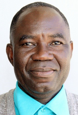
Thokozani Kanyerere
Thokozani Kanyerere is a Senior Lecturer at the University of Western Cape, where he has taught and conducted groundwater management research since 2013. He has 20 years of experience in university academic and research work. He received his MSc from the University of Malawi (2001) and MPhil from the Norwegian University of Science and Technology in Norway (2004). He obtained his PhD (2012) from the University of Western Cape in South Africa, where he assessed groundwater management practices for domestic use using the IWRM approach. He is involved in direct and developmental applied research work from a capacity-building perspective. His research interests are in groundwater/surface-water interaction, aquifer characterisation, groundwater recharge, and groundwater management with a focus on quality which enabled him to coordinate academic and groundwater projects. His passion is for water education for capacity development. Dr Kanyerere is a reviewer of several peer-reviewed journals and institutes.